Bronze Age / Iron Age
Thrapston has a late Bronze / early Iron Age ringworks, possibly a mini hill-fort, dating from around 700 – 800 BC which was partially excavated in the 1990s.
Roman
Thrapston is situated near to the crossing of two significant roman roads and it possible that there may have been a minor settlement near to the river. As the many housing estates within the town has been developed, several Roman artefacts have been found such as a vase, many coins and a Roman glass and pottery kiln.
Anglo-Saxon / Norman
A cemetery with several skeletons dating from the late Saxon period was found during construction work in Manor Close during the 1960s. At the time of the Doomsday Book survey in 1086, the settlement was called Trapestone and two important Norman knights, Odelin and Oger the Breton, both owned land. Chancery Lane was also the site of a small 12th century motte and bailey castle. Some remains of the motte can still be seen by looking for the rise on which some bungalows have been built.
Market & Fair Charters
In 1205 Baldwin de Vere, the Lord of the Manor, requested the permission of King John to hold a market in the town every Tuesday. King John awarded the market charter in return for two palfreys (small riding horses) and they are now represented on Thrapston’s civic badge and flag. The Charter is still celebrated in June every year, when the annual ‘Charter Fair’ is held on the High Street which is closed to traffic for most of the day.
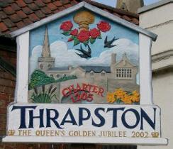
Town Board celebrating the Queen’s Golden Jubilee 2002
The Parish Church of St James
The earliest remains in the church date from mid-13th century although the earliest record is of monks from the Abbey at Bourne in Lincolnshire coming to serve the church around 1133AD. During the nineteenth century the ‘box-pew* balcony was added when significant refurbishment was carried out, which also included the rebuilding of the nave and both the north and south aisles. The vestry was rebuilt later in 1888.
Cemetery
As Thrapston grew in size the church yard became full and a new cemetery was needed. In September 1895, the newly formed Parish Council purchased 4.3 acres of land on Titchmarsh Lane, (now Oundle Road).
Buildings
A significant number of the historic buildings in Thrapston are listed and add character to the town. However, there are many other similar buildings that are not listed. Many buildings have Collyweston limestone slate roofing. Chancery Lane has a number of 17th and 18th century building and is probably the oldest part of the town. It is also where the former Tithe Barn is situated, currently occupied by a motor repair business.
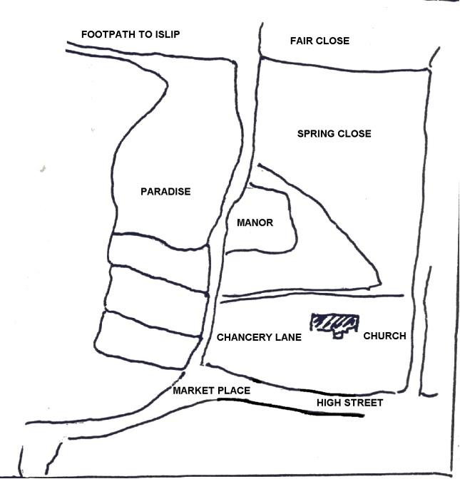
Map of the land names along Chancery Lane (Fair Lane)
The Courthouse Public House was originally the County Police Station and Court and was built in the 1890s.
River Nene
An Act of Parliament in 1724 proposed that the River Nene between Thrapston and Peterborough should be made navigable. It was completed in 1736. A further Act in 1756 proposed that it should extend to Northampton and in 1761 it became possible to sail from Northampton to Peterborough. The opening up of the River brought trade to the town but also provided better transport of goods from Thrapston to other destinations.
Railways
Thrapston had two stations: Thrapston Bridge Street which opened in 1845 for the London and North Western Railway (Northampton to Peterborough) Thrapston Midland Road which opened in 1860s for the Midland Railways (Kettering to Huntingdon, Cambridge) The last passenger train left Thrapston Bridge Street Station in 1964 and the line was used for goods traffic until May the following year when it finally closed.
The Town Walk
In 1972, following the removal of the railways in Thrapston, the Parish Council purchased from the British Railways Board, at a cost of £200, the 1.25 acres of trackway that now forms the ‘Town Walk’.
Iron Foundries
Over the centuries there have been a number of sites recorded within Thrapston where sand and stone have been extracted. By the early 19th century a number of small iron foundries were being established and were making very good use of the natural ironstone to found locally. The Nene Side Ironworks had humble beginnings in the 1850s but it became Smith & Grace Screw Boss Pulley Company, one of the town¡¦s major employers. It ceased operation in the late 1980s.
War Memorial
Kiln Close, which originally may have been part of the grounds of Thrapston House was purchased by the local council in 1920. The 2.5 Acres site was used to create the Peace Memorial Park which is now a recreation ground and the town¡¦s main war memorial. There is also a formal carved memorial in the Parish Church of St James. In 1950 the Parish Council purchased 6.4 acres of land on Chancery Lane to form the playing fields, as a permanent memorial for the Second World War casualties. The area was once known as ‘Fair Lane Close’ but is now called ‘Castle Playing Fields’, after the Norman Castle on the site
Nene Crossing
Records and archaeological finds suggest that there has been a crossing of the River Nene at Thrapston from very early times, initially as a ford at a low point of the river. 15th century records report a seven arch bridge on the present site. Later the bridge was extended to 24 arches but when the railway was built in the 19th century, the length was reduced and we now have the present ‘nine arch bridge.
The Washington Family Links
The Washington Arms, the origins of the National Flag of the United States, the famous “Stars and Stripes”, can be found on a stone tablet in the Parish Church of St. James. Sir John ( c1590 – May 1688) is buried in the St James Churchyard and was a great, great, great uncle of George Washington (1732 – 1799). The House in Thrapston in which Sir John Washington lived is now occupied by Vincent Sykes and Highham, Solicitors. It is known as Montague House from a doctor named Montague who later married into the Washington family and lived there.
No Comments
Add a comment about this page